The branch of science which deals with the structure and movement of earth’s crust is known as Geotectonic.
It includes the study of large-scale features like mountain chains, mid-oceanic ridge and oceanic trenches.
An investigation regarding the form pattern and genesis of these and other tectonic units have enabled geoscientists to ascertain the important characteristics of earth’s crust and reconstructs its evolution and geological history.
Composition of the Earth:
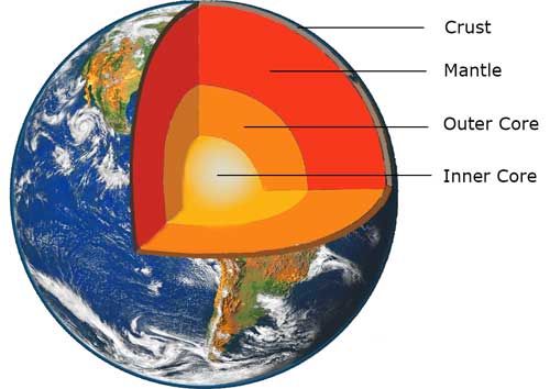
The Earth consists of layers of various composition and physical properties, principally
- The central core
- The peripheral core
- The mantle
- The lithosphere
 The Central core
The solid central core is round-shaped core lies beneath the cool, brittle crust and the mostly-solid mantle. The core is found about 2,900 km (1,802 miles) below Earth’s surface and has a radius of about 3,485 kilometres
The Peripheral core
The fluid peripheral core is a fluid layer about 2,400 km (1,500 mi) thickness. It is mainly composed of iron and nickel that lies above the Earth’s solid inner core and below its mantle
The Mantle
The viscous mantle is a layer inside a planetary body bounded below by a core and above by a crust.
The Lithosphere
The lithosphere is comprised of the layer and therefore the crust, the outer shell of the world. There are two sorts of the lithosphere, consistent with the crust resting on the solid mantle lithosphere (lithospheric mantle): the oceanic lithosphere features a 5 to 8 km thick oceanic crust (with a basaltic composition) and therefore the continental lithosphere features a 30km to 40km thick granitic-dioritic crust.
Major Plates of the Earth
The lithosphere is fragmented into the plates of variable shape and size. The edges of theses plates are called plate boundaries.
The Earth has 7 major plates
- Africa,
- Antarctica,
- Australia,
- Eurasia,
- North America,
- South America
- Pacifica
Besides these, there are a number of other minor plates Adria, Arabia, Caribbean, Nazca, Philippines and others.
Movement of Plates
Most of the plates are composed of continental and oceanic lithosphere. These plates move independently relative to at least one another, with restricted independence from the 7 large plates.
However, the relative, horizontal movements can be idealised as rigid body motions that produce space and friction problems at the contacts between adjacent plates.
Plate boundaries move and change shape. The interior is hot, space is cold. This difference will drive spontaneous convection processes in pursuit of equilibrium and hence the motion of lithospheric plates.
The crust of the earth
The crust of the earth is generally applied to the outermost, more or less rigid, the shell of the earth. This crust is separated from the underlying mantle by the Mohorovicic discontinuity or moho the surface below which the velocity of P-waves increases rather abruptly to 8.1 km/sec.
The rock constituting the earth’s crust fall into two groups:
- The Light rocks, including granites and related rocks which have a specific gravity of about 2.7. These rocks are rich in silica (about 70%) and next abundant constituent is alumina (about 15%). These rocks are hence collectively designated by the phomonic term seal.
- The heavier rocks, including basalts and related rocks (specific gravity 2.9-3.1) and ultramafic rocks (specific gravity of up to 3.4) in which silica is reduced (40-50%) and the second, most abundant constituent is magnesia (about 15%). These rocks are collectively designated as sima.
The surface separating the sial from sima is often called Conrad discontinuity. Its presence is, however, not observed everywhere.
Nature of the crust in different Areas
The nature of the crust in the continental area is quite different from that in the oceanic areas. Roughly one-third of the earth’s surface exposes the continental crust and two-thirds the oceanic crust.
The continental crust has a thickness of about 30-40 km. The uppermost part may be composed of sedimentary rocks or volcanic effusive or their metamorphic equivalents. Below this is a layer of sail the proper which grades downwards into sima.
The continental crust has a thickness of about 65-70 km in the Himalayan region. This is reduced to 37 km in the region of peninsular India with the sial and sima layers being of about equal thickness. The cover of Decan traps in western India is of the order of 1.5 Kms. In the offshore region, the continental crust thins out being about 15 Kms thick in the vicinity of Maldive island
Why the Earth is not spheroid?
A rotating mass like the earth should ideally have the shape of an oblate spheroid. However, in the case of the earth, it is not so. The surface is irregular with the area of elevation, such as the mountains and plateaus, and of depression, like the ocean basins.
This is due to the fact that the rocks everywhere are not of the same density. In areas of continental crust, where the sialic rocks are important, the gravity is comparatively low and the region is elevated.
On the other hand in regions of oceanic crust only Simatic rocks are present, the gravity is comparatively high and depressions result. This is so because there is a tendency for the outer surface of the earth to attain gravitational equilibrium or isostasy.
Concept of isostasy
The concept of isostasy, which was put forward in 1889 by American geologist C.E. Dutton.
It can be visualized by taking the example of series of wooden block of unequal height floating in water. It is seen that the block emerges above the water- surface in amounts proportional to their respective heights. The blocks are in a state of hydrostatic balance.
This concept of isostasy implies that below the earth’s surface there is a minimum level at which the pressure due to overlying column of rocks is the same at all places
Why Crustal rise continues today?
The principle of isostasy explains, why in some part of the northern hemisphere the surface is rising at the rate of 5 to 10 meters per 1000 years. Some 25000-50000 years ago these areas were covered by extensive ice sheets. When the ice melted a great load was removed and the crust began to rise in order to restore isostasy at a rate in keeping with ice melting. Crustal rise, therefore continues today.
